Proposed modeling elements include the following prototype considerations:
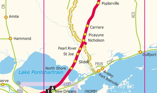
LDE – Poplarville NO 125.0
Poplarville mainline and Blue Terra Blueberry farm.
POPLARVILLE, MS AND MOSELLE, MS
Cars left standing at the following locations must have 100% hand brakes applied: Poplarville, MS and Moselle, MS
Signaled Siding (SS) between Poplarville MP NO 125.0 and Derby MO NO 131.6 is 11,790 ft. or 2.24 miles.
LDE – Mississippi tracks through Carriere, Picayune, Nicholson, NASA Spur
Track continues with mainline and NASA spur near Nicholson, industry sidings and Picayune downtown with tracks onto Carriere. Including NS office, engine yard, industries include aggregate plant, Shale Support, Power Dynamics, Heritage Plastics. Highway 11 parallels the track through Picayune with Nicks Meat Market, Amtrak Station, Post Office, Granny G’s stand, and Shay park.
PICAYUNE, MS – NO 149.1
Do not exceed 8 MPH while weighing cars on in-motion scale at Heritage Plastics, MP NO 149.7.
Signaled Siding (SS) in Picayune is 8,520 ft. or 1.61 miles.
Picayune Amtrak Passenger Station
Picayune is an Amtrak intercity train station at 200 South Highway 11, in the heart of downtown Picayune, Mississippi. The station is served by Amtrak’s Crescent passenger train. The station house was built in 2008 as a replacement for an open covered shelter. Like its predecessor, however, it is a flag stop, and only stops here when passengers have tickets either to or from the station. Since the “suspension” of the Sunset Limited east of New Orleans in 2005, Picayune has been the only Amtrak station on the Mississippi Gulf Coast. General information:
Location: 200 South Highway 11, Picayune, Mississippi, United States
Coordinates: 30.5244°N 89.6804°WCoordinates: 30.5244°N 89.6804°W
Owned by: City of Picayune
Line(s): Norfolk Southern Railway
Platforms: 1 side platform
Tracks: 2
NICHOLSON, MP NO 152.0
LDE – Pearl River and PR Bridge MP NO 159.4 PEARL RIVER BRIDGE
Track continues through Pearl River with PR bridge and Interstate highway I-10 alongside.
Signaled Siding (SS) between Pearl River Bridge NO MP 159.4, and Pearl River, LA MP NO 160.1, is 5,900 ft. or 1.12 miles.
LDE – Northshore/Slidell/St Joe – MP NO 167.3 SLIDELL
Track continues through the Northshore, Slidell and St Joe. Slidell Amtrak station, siding in Pearl River, 84 Lumber.
Signaled Siding between MP NO 169.0 WOODS, LA and MP NO 173.4 NORTH DRAW is 8,144 ft. or 1.54 miles.
LDE – Pontchartrain Bridge and drawbridge
Continue track through East New Orleans through and over Lake Pontchartrain.
NS system map of this area is displayed below: